Experts: Trillions of maps say NC Republicans gerrymandered
Plaintiffs have wrapped up their case in a trial over North Carolina's new voting maps. Lawmakers' defense will be heard Wednesday.
Posted — UpdatedA parade of mathematicians and political scientists calling North Carolina’s election maps partisan gerrymanders continued Tuesday before a panel of judges tasked with deciding whether those maps pass constitutional muster or must be redrawn before the state’s 2022 elections.
Experts brought in by a trio of legal teams looking to force a redraw said the math is clear: Maps drawn by the General Assembly’s Republican majority were skewed to help elect Republicans. Trillions of maps created for comparison’s sake by multiple computer algorithms tell this story time and again, they testified.
“I find the enacted maps to be significantly skewed in a partisan way, in favor of Republicans,” Moon Duchin, a mathematician at Tufts University said.
“Significant deviations from what we would expect if the legislature had followed a neutral process,” said Daniel Magleby, a political scientist at Binghamton University. “A high level of bias against Democratic voters statewide.”
The trial, which is before a state-selected panel in Wake County Superior Court, combines multiple lawsuits. Voting rights groups and other plaintiffs sued state Republican leaders, alleging that the new maps are so biased toward Republicans that they violate the right to a free and fair election. Republican defendants say they complied with map-drawing guidelines.
Tuesday brought the plaintiffs’ side of the case to a close, and attorneys for the state’s legislative leadership began making their own arguments, which will continue Wednesday. WRAL News is streaming the proceedings, which are scheduled to end with closing arguments on Thursday.
An appeal to the state Supreme Court is likely. The high court is expected to decide what to do with the congressional and state legislative maps before the primary elections, which were delayed from March to May to make time for the ongoing trial.
The lawmakers’ defense started with N.C. State political scientist Andrew Taylor, who said the North Carolina constitution gives legislators wide latitude on redistricting, making it difficult for plaintiffs who say these maps violate the constitution’s free elections clause.
Taylor said he compared North Carolina’s constitution to those in other states and that it gives the General Assembly nearly as much discretion, if not as much, as any other state. He also said it’s “practically impossible” to keep partisanship out of the redistricting process, though it’s up to the courts to decide how much partisanship can be allowed.
The plaintiffs, various progressive good-government groups and individual voters argue that North Carolina’s maps are extreme partisan gerrymanders, and their mathematicians have testified that the evidence is so overwhelming it suggests ill intent from the Republican majority that drew them.
“I don’t think you get that large and durable of an effect by accident,” Duchin, the Tufts mathematician, testified Tuesday.
Attorney Tom Farr, who represents GOP lawmakers, pressed Magelby, the Binghamton political scientist, on this point, asking whether there could be something other than partisan intent dictating the map lines. That’s a key argument for Republican lawmakers.
“I’m not here to talk about intent,” Magelby said. “I’m here to talk about effect. And there was a real partisan effect.”
Magelby, Duchin and others say their computer models repeatedly spit out maps more likely to elect Democrats than the ones Republican lawmakers approved last year.
Throughout their testimony, GOP attorneys noted these mathematicians and political scientists haven’t interviewed lawmakers and can’t know their intent. They suggest the state’s political geography—a self-sorting of Democrats living in cities and Republicans more spread out around the state—is responsible for much of the Republican advantage in these maps, despite a close split between the two main parties in statewide election results.
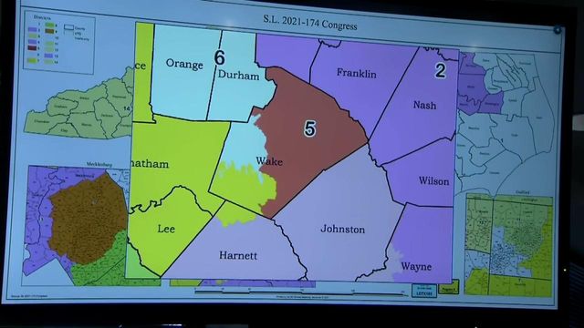
Experts for the plaintiffs don’t deny this sorting, but they say it can’t explain the full tilt of the maps. The congressional map as it stands now would likely elect 10 Republicans and four Democrats, experts say. The state House and Senate maps would all but guarantee Republicans continue to hold majorities in those chambers, and they might usher back in super majorities, allowing GOP lawmakers to overcome vetoes from Democratic Gov. Roy Cooper.
The Republican defense also involves picking at the methodology of various mathematical attacks on their districts, and many of the questions asked Tuesday suggested experts failed to fully account for rules North Carolina lawmakers must adhere to in drawing districts, which would skew the results that repeatedly show the current maps as outliers.
Witnesses said they were confident in their results.
Tuesday also brought testimony about the map-making process, which Republicans have lauded as the most transparent in state history, largely because it was live streamed online, where people could watch lines move in real time.
Tyler Daye, an analyst for Common Cause, one of the plaintiffs in this trial, said that transparency only went so far, though, and that the process of creating the maps was often hard to follow.
He also questioned whether lawmakers truly drew maps without relying on racial or voter history data, something they promised to do. Tyler Daye said people brought paperwork in and out of the room and that lawmakers often drew more competitive districts, tweaking them later to be stronger for Republicans.
Daye also said lawmakers and aides left the drawing room with detailed copies of their maps that could have been input into other map-making software to determine likely partisan outcomes. Daye acknowledged, though, that he has no evidence lawmakers ran that analysis, which key legislators in the process have denied doing.
Judges in the trial are expected to issue an initial decision by Jan. 11.
• Credits
Copyright 2024 by Capitol Broadcasting Company. All rights reserved. This material may not be published, broadcast, rewritten or redistributed.


